Death Valley National Park, which straddles both California and Nevada, is hard to beat when it comes to geological extremes. Home to the lowest point in North America and one of the greatest vertical rises above local terrain of any mountain in the contiguous United States, Death Valley is an example of the Earth’s vast geological contrasts, all located within a 3-million-acre national park.
The largest, hottest and driest of the national parks in the United States, Death Valley provides stunning views of a vast desert that includes incredible geological sites you won’t see anywhere else. It is truly exceptional.
Geologic Forces in Death Valley National Park
“The number of geologic forces at work in Death Valley makes it unique,” says David Blacker, executive director of the Death Valley Natural History Association. “Erosion, faulting, the pull of the basin and range formations — add a double rain shadow (an area of significantly reduced rainfall behind a mountainous region), and you get a unique landscape that has to be seen to believe.”
Death Valley’s features include deep valleys, high mountains and a variety of unusual rock formations that have developed over millennia. To stand in Death Valley is to look through a window into the past.
“The earliest Death Valley rocks were sedimentary, and deposited about 2.5 billion years ago, while the area we know as Death Valley was under a shallow sea,” says Blacker. “Ten million years, ago Death Valley was a Lowland Basin with grasslands. Of course, over that time it has become much more arid, and the double rain shadow has locked it in as the hottest and driest place in North America.”
Exploring Death Valley National Park
While it can take years of backcountry exploration to discover all the geological wonders of Death Valley National Park, a handful of spectacular sites provide vehicle access to visitors who want to get a taste of what this amazing place has to offer.
Artists Palette
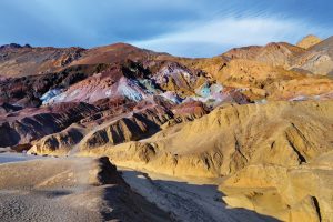
One of the easiest to get to and most beautiful spots in Death Valley National Park is the Artists Palette. Made up of hills splashed with the colors of red, green, orange, yellow, purple, pink and blue, the Artists Palette was created from volcanic deposits rich in iron oxides and chlorite. Iron compounds produce red, pink and yellow colors, while the decomposition of tuff-derived mica produces green. Manganese produces purple and blue.
Formed during the Miocene age, the hills are made of cemented gravel, playa deposits and volcanic debris, which is 5,000 feet thick in places. The colors were created by chemical reactions during various forms of weathering.
The hills themselves were formed by water erosion and can be viewed from the ninemile Artists Palette Drive, a winding, paved road that gives visitors a chance to experience this phenomenon up close. The best time to see the hills is at sunrise and sunset when the angled sunlight provides brighter colors on the rocks—although the colors are stunning at any time of day. Nearby salt flats and the striking Black Mountains are also visible from the road.
Zabriskie Point
Most visitors to Death Valley National Park go to Zabriskie Point to take in the views of the surrounding landscape at sunrise and sunset. But those interested in the site’s geological treasures will appreciate this spot at any time of the day.
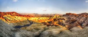
The badlands visible from Zabriskie Point make up the 7,000-foot thick Furnace Creek Formation, which consists of saline muds, gravels from nearby mountains, and ash from the once-active Black Mountain volcanic field. The formation appears as tan-colored sandstone and clay rocks showing deep erosion, with dark-colored rocks on the ridgelines that were created by volcanic eruptions. Look to the west and you will see Red Cathedral, a geological formation of steep cliffs composed of red-colored oxidized sandstone.
Zabriskie Point is easily accessible to visitors, with a large parking area just off the main park road and a short walk to a vista point. To avoid the crowds, plan to see it in the middle of the day since most people visit Zabriskie Point at dawn and dusk.
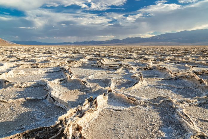
Badwater Basin
The lowest point on the North American Continent, Badwater Basin is more than just an anomaly at its depth of 282 feet below sea level. It is also an endorheic basin, which means water that gathers here does not flow to any external bodies of water. Over tens of thousands of years, water that collected here only left the basin through evaporation. The result is a 200-square-mile basin floor made up of mostly sodium chloride—table salt—with calcite, gypsum and borax thrown in. This accumulated sediment and salt is more than 11,000 feet deep.
You can view the expanse of this snow white salt from a platform just off Badwater Road, or venture onto it by walking on a boardwalk that stretches one mile across the basin floor. The cliffs of the Black Mountains are just behind you to the east, and you’ll see a marker on a cliff showing how far you are standing below sea level. To your west, the towering 11,039-foot Telescope Peak rises out of the valley floor, giving you a dramatic perspective you won’t see anywhere else in North America.
Be sure to look into the tiny and highly salinized spring located near the beginning of the boardwalk. It is home to the Badwater snail, an endangered fish that lives nowhere else on Earth.
Ubehebe Crater
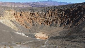
Located in the northern section of Death Valley National Park, the Ubehebe Crater is a 600-foot-deep hole in the ground. Caused by a volcanic eruption that took place about 2,000 years ago, the half-mile diameter crater is the product of a maar (explosion pit) volcano. The Ubehebe Crater resulted when molten lava came into contact with groundwater at about 200 feet below the surface. The heat from the lava caused the water to flash into steam, creating incredible pressure that built up and exploded outward, leaving the massive crater in its wake.
As you drive from North Highway up to the Ubehebe Crater parking area, you’ll see cinders from other similar volcanic explosions covering much of the surrounding area. Just north of Ubehebe and other surrounding craters, you can see cinders on the dry bed of ancient Lake Rogers, located on the valley floor. The cinders covering most of the area came from the Ubehebe Crater, and are 50 feet thick at the crater rim.
Colorful layers in the crater’s eastern wall are the result of the explosion. The alluvial fan inside the crater includes fanglomorate, as well as sandstone and older conglomerate deposits, loosely cemented together by calcite. Most of the rock inside the crater is either volcanic or metamorphic.
The moderate, 1.5-mile Ubehebe Rim Trail loops the rim of the crater and provides views of the sedimentary layers left behind by the explosion. If you want to get closer to the interior of the crater, a more rugged trail descends to the bottom.
Racetrack Playa
Since Death Valley National Park’s creation in 1933, both visitors and scientists have wondered over the phenomenon of the Racetrack Playa. This level, dry lakebed is home to rocks made from dolomite and syenite—the same minerals found in the surrounding mountains. The rocks weigh from a few ounces to several hundred pounds and are called the Sailing Stones because they show evidence of movement across the dry lake bed. While observers have not seen the rocks actually moving, trails in the mud-cracked sediment and changes in the rocks’ location indicate they are anything but stationary.
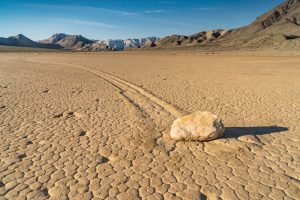
In 2014, scientists conducted research that seems to explain what makes the rocks move. Water coming down off the adjacent mountains settles in the lakebed, and then freezes, creating a thin layer of ice. When slight winds blow while the ice is present, the rocks slide, leaving a trail in the mud.
Although this may have solved the mystery, the Racetrack Playa is still a sight to behold. Head there from Ubehebe Crater, which is several miles to the north. You’ll need a 4-wheel drive vehicle with high clearance to drive the road that leads to the Racetrack from Furnace Creek, and is only recommended in the wintertime.
Death Valley National Park – A Rockhound Destination
When it comes to geological wonders, few places on Earth can compete with the splendor of Death Valley National Park. Not only it is a spectacular destination for rock hounds, it’s also a goldmine for researchers who want to learn about the geological history of the planet.
“The climatic conditions make it an ideal geologic laboratory because the lack of vegetation makes it so there is little to obscure rock characteristics,” says geologist Gregg Wilkerson, co-author of Roadside Geology and Mining History of Death Valley. “Over the next million years, the pull-apart basin will continue to grow, the valley will get broader and the mountains will get higher.”
Death Valley has been around since long before humans walked the Earth, and will likely still be there after we are gone. Spending some time in this amazing place will leave you with a sense of awe that will last a lifetime.
Visiting Death ValleyDeath Valley National Park is a stunning jewel in the national park system, but it can also be dangerous for visitors who are not prepared. Follow these guidelines to stay safe: • Avoid visiting the park at times of extreme summer heat. • Always carry several gallons of drinkable water in your vehicle. • Stay on marked park roads; don’t explore. • If you want to walk in an area without an official parking area, don’t venture out of sight from your vehicle. • Don’t rely on your mobile phone. Many areas of the park do not have service. • Stop at one of the park’s visitor centers for maps and more information on staying safe in Death Valley. • Be sure to visit nps.gov/deva/index.htm to plan your stay. |
This story about the geology of Death Valley previously appeared in Rock & Gem magazine. Click here to subscribe! Story and photos by Audrey Pavia.


