
Mount St. Helens is the site of the deadliest and most destructive volcanic eruption in American history. On May 18, 1980, the catastrophic blast literally blew away the mountain’s summit, killing 57 people, devastating forests and wildlife, and destroying homes, highways and surrounding communities in Washington state.
Today, Mount St. Helens is known as “America’s volcano” and is the namesake attraction at Mount St. Helens National Volcanic Monument. Although the volcano is now quiet, geologists warn that future eruptions are likely.
Key Takeaways
- Mount St. Helens produced the deadliest volcanic eruption in U.S. history on May 18, 1980.
- A massive landslide triggered a lateral blast that destroyed forests, roads, and wildlife across a wide region.
- The eruption removed more than 1,300 feet of the mountain’s summit and created a large crater.
- Ash from Mount St. Helens spread across multiple U.S. states and parts of Canada within hours.
- The volcano remains active today and is closely monitored for future eruptions.
- Mount St. Helens National Volcanic Monument preserves the area for research, education, and recovery observation.
- “Helenite,” a glass-like material sold in jewelry, is only loosely connected to volcanic ash.
Mount St. Helens Geology
Located 100 miles south of Seattle and 50 miles north of Portland, Oregon, Mount St. Helens is part of the Cascades Volcanic Province, a volcanic arc extending from southwestern British Columbia to northern California. Within this geological province are 20 major volcanoes along with hundreds of lesser volcanic features such as vents, domes, lava flows and cinder cones.
The Cascades Volcanic Province was created by tectonic plate movement as the North American Plate subducts the oceanic Juan de Fuca Plate, increasing temperatures of free water molecules from subducted rock. This superheated water then moves upward into the overlying North American Plate, where it melts mantle rock into magma, which, in turn, rises to the surface to explain the region’s volcanic activity. Beneath Mount St. Helens, magma accumulates in two chambers, one 3 to 7 miles beneath the surface, the other 7 to 25 miles deep.
(USGS)
Eruption History
Mount St. Helens began forming only about 40,000 years ago. Studies of volcanic sedimentation reveal eight ancestral eruptive phases of widely varying intensities and duration.
Geologists believe that Mount St. Helens had achieved its pre-eruption summit elevation of 9,677 feet and distinctive, cone-like symmetry just 2000 years ago. The volcano’s last ancestral eruptive stage, which began in 1800 and lasted 57 years, was the first to be supported by oral and written records. This phase started with an explosive eruption which, while comparable in size to the 1980 eruption, did not destroy the summit cone. A major eruption in 1831 produced ash clouds that tinted the noonday sunlight bluish-green as far away as Maryland and Virginia.
Mount St. Helens: Prelude to the 1980 Eruption
Mount St. Helens had remained dormant and deceptively quiet since 1857. The first hint of reawakening came on March 18, 1980, when movement within the volcano’s upper magma chamber generated a series of small earthquakes. Two days later, a much stronger, 4.1-magnitude earthquake, followed by a swarm of smaller quakes, rocked the mountain. On March 27, steam explosions just below the summit formed a new crater 250 feet across, emitted a 7,000-foot-high ash cloud, and created a visible, three-mile-long fracture across the entire summit area. A week later, new steam explosions sent ash clouds soaring to 11,000 feet with measurable ashfalls reported 150 miles away. By March 30, another new crater was emitting blue flames and steam-ash clouds.
Concern grew when United States Geological Survey volcanologists detected a bulge high on the north side of the mountain. By the end of April, this deformity measured 1.5 miles in diameter and its upward displacement of 300 feet was growing at the rate of six feet per day. On the advice of USGS geologists, Washington’s governor, who had already declared a state of emergency, now issued a “red zone” order that barred unauthorized entry into the area surrounding the volcano.
On May 7, steam eruptions resumed along with new earthquakes centered directly below the still-growing bulge. When this activity ceased a week later, it appeared that the volcano was returning to dormancy.
Mount St. Helens Eruption Begins (May 18, 1980)
But as May 18 dawned, USGS observers noted an ominous change in the preceding week’s activity pattern that hinted at an imminent eruption, perhaps on a catastrophic scale. At 8:32 a.m., a massive magmatic movement beneath the bulge generated a powerful, 5.2-magnitude earthquake that caused the bulged side of the mountain to slide. This landslide, the largest in recorded history, moved at a speed nearing 150 miles per hour to cover 24 square miles with rubble to an average depth of 150 feet.
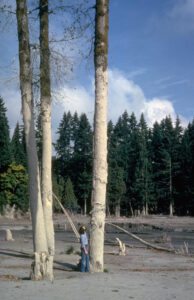
The landslide exposed the magma in the volcano’s neck to eliminate all containment pressure. The underlying mass of gas-charged, partially molten rock and high-pressure steam then exploded upward to destroy the entire top of the mountain. The associated near-supersonic lateral blast devastated forests as far as 19 miles from the crater. An enormous pyroclastic flow of gases, partially molten rock, and ash raced down the mountain at speeds nearing 200 miles per hour to cover an area of 240 square miles. These flows melted the mountain’s sizeable glaciers, generating huge mudflows that destroyed roads and bridges while filling lower lakes to record levels.
Blast, Ash Cloud, and Regional Devastation
Within 10 minutes of the start of the eruption, a massive ash column rose 15 miles (79,000 feet) into the sky. Major ash eruptions continued for 10 straight hours, depositing an inch of ash on Spokane, Washington, 250 miles distant, and reducing visibility there to 10 feet. This period of vigorous eruption dropped an estimated half-billion tons of ash over 11 states and five Canadian provinces. The ash cloud could be seen two days later 975 miles away in Denver, Colorado.
The eruption radically transformed Mount St. Helens, destroying its beautiful, Mount Fuji-like symmetry by removing the mountain’s uppermost 1,300 vertical feet and leaving a gaping, two-mile-diameter crater. In an instant, the eruption reduced the mountain’s elevation from 9,677 feet to 8,363 feet.
The eruption’s economic impact was estimated at $1.1 billion ($3.6 billion in 2025 dollars). Along with a human death toll of 57, it claimed the lives of some 7,000 elk, deer and bear, along with millions of salmon. Also lost were 200 houses, 47 bridges, many miles of highways and railroad tracks, millions of dollars in agricultural crops and three billion board feet of prime timber.
(USGS)
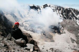
“Hell on Earth”
In the months following the eruption, several newspaper accounts described the immediate area surrounding Mount St. Helens as “hell on Earth.” The USGS estimated the eruptive energy as equivalent to that of a 24-megaton nuclear bomb, making it 1,600 times more powerful than the nuclear bomb blast at Hiroshima. As long as a month after the eruption, some pyroclastic flows miles from the mountain retained temperatures as high as 250°F.
Mount St. Helens Today
On August 27, 1982, a little more than two years after the eruption, President Ronald Reagan established Mount St. Helens National Volcanic Monument, setting aside a 172-square-mile tract surrounding the volcano for research, recreational and educational uses. The area within the monument has been left to recover naturally.
The Mount St. Helens Visitor Center opened in 1987 just outside the monument. Exhibits focus on the area’s history and native culture, along with the natural history of the volcano, its eruption and the slow recovery of vegetation and wildlife. In its first two years, the center hosted 1.5 million visitors. Exhibits were expanded in 2023 to include artwork and displays depicting the relationship of the Cowlitz Indian Tribe to the mountain and its environs. The center now hosts more than 300,000 visitors each year.
The Johnston Ridge Observatory, located within the monument and just four miles from Mount St. Helens, also opened in 1987. It now welcomes visitors daily from mid-May through October with exhibits on the volcano’s geological history, along with eyewitness accounts of the eruption and recent scientific advancements in monitoring and predicting volcanic activity. The observatory is named for 30-year-old USGS volcanologist David A. Johnston and is near the campsite where he lost his life during the eruption.
The Origin of Helenite from Mount St. Helens Ash
Part of the legacy of the Mount St. Helens eruption of May 18, 1980, is vested in a green “gemstone.” Its story began shortly after the eruption when timber company crews were salvaging equipment buried in volcanic ash. A workman noticed that high-temperature, acetylene cutting torches were melting the silica-rich ash, which then solidified as a dark, translucent-to-opaque glass.
This material caught the attention of someone with gem or lapidary knowledge because in 1983, a new, faceted, transparent, glass-like gem, emerald-green in color, appeared in regional jewelry and tourist shops. It was sold under the name “helenite” and was purportedly made from melted Mount St. Helens volcanic ash. Some sellers even implied it had been extruded in the eruption in rough form, ready for faceting. Catchy marketing phrases described helenite as “Tears from a Volcano,” “A Beautiful Piece of the Volcano,” and “The World’s Newest Stone.”
Is Helenite Really Made from Mount St. Helens Ash?
Set in pendants, rings, bracelets and earrings, this faceted helenite sold quickly and soon attracted the attention of the Gemological Institute of America. GIA gemologists first noted that the hardness and durability of helenite were similar to those of window glass. They next melted samples of Mount St. Helens ash to produce a blackish glass, and then compared its properties with those of helenite. Their conclusion, published in the summer 1986 issue of Gems and Gemology, stated that “the green glass claimed to be made from ash from the 1980 eruption of Mount St. Helens has significantly different properties and composition from glass actually made entirely from the ash. [Helenite] contains at most 5% to 10% of this ash, if any.”
The logical conclusion, then, is that helenite is essentially commercial green glass that may or may not contain small amounts of Mount St. Helens volcanic ash. If this is true, any token amount of ash present is there only to establish a marketing connection with the volcano.
Was that the end of Helenite? Not at all. Helenite is still sold nationally today, not only in green, but in red, blue and yellow colors. Its continued marketability and consumer appeal rest not on any gem qualities, but on its tenuous association with the intriguing name of Mount St. Helens.
Frequently Asked Questions
What caused the Mount St. Helens eruption in 1980?
The eruption was triggered by a massive earthquake that caused the north flank of the volcano to collapse, releasing pressure and leading to a catastrophic lateral blast.
How many people died in the Mount St. Helens eruption?
Fifty-seven people lost their lives during the 1980 eruption, making it the deadliest volcanic event in U.S. history.
How tall was Mount St. Helens before and after the eruption?
Before the eruption, Mount St. Helens stood at 9,677 feet. Afterward, it lost more than 1,300 vertical feet, significantly reducing its elevation.
Is Mount St. Helens still active?
Yes. Mount St. Helens is still considered an active volcano and has experienced smaller eruptions and dome-building activity since 1980.
Can Mount St. Helens erupt again?
Yes. Scientists at the USGS consider Mount St. Helens the most likely volcano in the Cascades to erupt again in the future.
What is Mount St. Helens known for today?
Today, it is known for its 1980 eruption, ongoing scientific study, and recovery of ecosystems within the Mount St. Helens National Volcanic Monument.
What is helenite and is it real volcanic glass?
Helenite is a glass-like material sold in jewelry and often linked to Mount St. Helens. However, studies show it is mostly commercial glass with minimal volcanic ash content, if any.
Mount St. Helens Today and Ongoing Monitoring
Although Mount St. Helens has not had a major eruption since the cataclysmic event of May 18, 1980, the mountain has hardly been sleeping. Just months after the eruption, volcanologists noticed a new dome forming within the still-smoking crater. From 1989 to 1991, numerous small steam explosions and dome-building eruptions occurred, some producing large ash clouds. In 2005, a plume of steam and ash rose 35,000 feet above the crater. Activity continued until 2008, ending with the collapse of a lava dome within the crater that produced large ash clouds and a 3.5-magnitude earthquake.
And what about the future? According to the USGS, of the 20 major volcanoes in the Cascades Volcanic Province, Mount St. Helens is the most likely to erupt again during our lifetimes, and with the same eruption type, frequency and magnitude observed in 1980. But because much of the original summit has been replaced by a large, shallow crater, neither a massive debris avalanche nor a major lateral blast comparable to that of 1980 is expected. Just when this next eruption will occur is not known and that’s part of the intrigue of Mount St. Helens as “America’s volcano.”
This story about Mount St. Helens appeared in Rock & Gem magazine. Click here to subscribe. Story by Steve Voynick.


