
By Robert Beard
The Organ Mountains are one of the most stunning ranges in New Mexico. Anyone driving past Las Cruces on Interstate 10 will have an excellent view of the mountains. The granitic core of the range forms a jagged, sawtooth pattern east of the Rio Grande. Early Spanish explorers thought they resembled the organ pipes of European cathedrals, and the mountains were referred to as Los Organos, or the Organ Mountains.
Like all mountain ranges in New Mexico, the Organ Mountains were painstakingly explored by prospectors searching for gold and other metals. Virtually all near-surface deposits of metals were discovered quickly and mined if they had enough ore. The Organ Mountains were no exception, and several former mines lie along the flanks of the mountains.
While the Organ Mountains have several former mines, many are inaccessible for mineral collectors. Much of the eastern side of the Organ Mountains is part of White Sands Missile Range, and it is not possible to access any mines in this area. Private land and fences also block access to many of the mines that are not within the Missile Range. Many of the mines that remain accessible can take considerable effort and time to reach.
Turning to Mine Memoirs for Information
Fortunately, there is an area just north of the Organ Mountains that has some easy-to-reach mine workings with collectible minerals. This is the area of the former Memphis mine, which is just north of U.S. Route 70 and northeast of the town of Organ. The mine lies along the foothills of the San Agustin Mountains, which are just north of the Organ Mountains. The USGS topographic map for the area, which is Organ, New Mexico, indicates there are three shafts in the area of the mine.
One of the best references on the geology of the Memphis mine area is Memoir 36 of the New Mexico Bureau of Geology and Mineral Resources. “This is Geology of the Organ Mountains and Southern San Andres Mountains,” by William Seager, and it was published in 1981. This outstanding guide is available at https://geoinfo.nmt.edu/publications/monographs/memoirs/36/. This download is extremely useful since it also has the geologic maps that go with the report. Many online reports only provide the text and do not have key maps.
The Memphis mine reportedly produced $200,000 to $400,000 worth of copper, zinc, and silver during its operation. The deposits are described in Seager’s paper as replacements of west-dipping strata of Lead Camp Limestone adjacent to the Sugarloaf Peak quartz monzonite porphyry. The Lead Camp beds contain ore at four different horizons, separated by marble or barren calc-silicate rock, which Seager referred to as garnetite. The deposits are tabular and dip west about 40 to 70 degrees, and have been explored by open cuts, shafts, and drifts to depths of about 200 feet. The primary ore minerals were chalcopyrite, sphalerite, and malachite, while azurite, chrysocolla, and hemimorphite formed in the oxidized zone that extends to the bottom of the workings.
A large body of chalcocite was also reportedly found at shallow depths in the easternmost ore horizon. Gangue minerals, which are waste minerals extracted with the ores, are mainly quartz, pyrite, hematite, and “especially garnet.” The mention of “especially garnet” is worth noting, as this indicates that garnet is likely a common mineral that can be found at these workings.
The area is also described in detail within a Geology M.S. thesis by Thomas Glover from the University of Texas at El Paso. This thesis, dated 1975, is entitled “Geology and Mineral Deposits of the Northwestern Organ Mountains, Dona Ana County, New Mexico,” and is available as an open file report from the New Mexico Bureau of Geology and Mineral Resources at https://geoinfo.nmt.edu/publications/openfile/downloads/0-99/63/ofr_63.pdf.
Formation Studies Draw Debate
Glover described the mineralization as occurring within the Permian Hueco Formation. The Lead Camp limestone described as the host rock by Seager can be considered to be within this formation, even though there is still debate over the stratigraphic nomenclature for the region. Glover noted that the garnet was andradite, which is an iron-rich garnet, and that diopside and wollastonite also formed as replacement minerals during the pyrometasomatic stage of mineralization. Glover described three shafts at the site, which he listed as the Roos, Zinc, and an unnamed small shaft. He said the main ore minerals were malachite, azurite, chrysocolla, and complex sulfides, and he also noted that chalcocite and massive sphalerite were also encountered in the Roos and Zinc shafts, respectively. The Roos, Zinc, and a small unnamed shaft are apparently the three shafts that are shown on the Organ, New Mexico, topographic map.
Another source with information on the Memphis Mine is also one of the earliest publications on the Organ Mountains. This is “Geology of the Organ Mountains,” which is Bulletin 11 of the New Mexico Bureau of Mines and Mineral Resources, by Charles Dunham.
The bulletin was published in 1935 and is available at https://geoinfo.nmt.edu/publications/monographs/bulletins/downloads/11/Bulletin011.pdf. Dunham said that the Memphis Mine was discovered prior to 1882 and that a small water jacket smelter was operated on the property. The last work was completed between 1927 and 1929 by the Memphis Corporation. The geologic description is consistent with the information reported by both Glover and Seager.
Before going to the area I also checked the land status of the area using the Map Viewer for U.S. Bureaus of Land Management (BLM) administered land in New Mexico, which is available at https://www.arcgis.com/home/item.html?id=7c417fa0eab24661bd5050c3113c580d. This mapping is based on BLM information and it is actually provided by ESRI.com. The map showed that the area has both land that is administered by the BLM land and private land.
Visiting the Memphis Mine
BLM-administered land is generally open for mineral collecting, as long as it does not have any active claims. Private land may or may not be posted, and it is often difficult to determine private land in former mining districts if the areas are not clearly fenced or posted as such in the field.
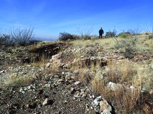
I first visited the site of the Memphis Mine in late December 2013. I visited the area with my brother-in-law, Mike, and my son, Daniel. We did not have a four-wheel-drive vehicle so we parked on the north side of County Road D087 and hiked to the mines. There were no gates, fences, or other signs indicating that mineral collecting or access to the mines was not allowed, and the boundaries of private land were not marked or fenced. We did not see any indications of any active mining claims. This hike to the mines was a short walk and we were soon on top of several mine dumps. We did not see any rattlesnakes, but it was undoubtedly too cold. This place will likely have a lot of snakes when the temperature is right.
The area had some concrete foundations, which must have been the foundations for the former mill or water jacket smelter that was reported to be on the mine site. The dumps had an abundance of minerals, and there were several signs of previous rockhounds, such as freshly broken and piled rocks. I noticed an area near the foundations that was covered with an abundance of white rocks, and closer inspection revealed these were pieces of coarse white marble. Much of the marble was nearly snow white. In addition to the marble, I found several pieces of coarse calcite.
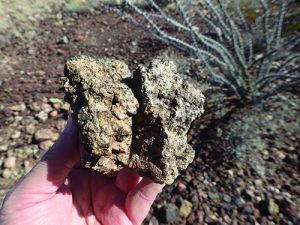
Some of the other dumps had garnet-rich rocks. Most of the garnet was massive, but some small individual crystals could be found with some effort. The garnet was generally light brown to light green, which is typically the color of andradite. The rocks were extremely hard, and it was often difficult to break off the garnet-rich sections.
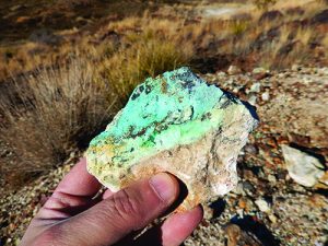
Some of the dumps had a lot of oxidized hard rocks that were mostly dark brown limonite. They were dense and had a high iron content. Malachite was also common on the dumps. The malachite was generally light to dark green and formed as a crust or coating on the rocks. Many of the rocks also had coatings of light blue chrysocolla. However, I did not see any deep blue azurite. I thought this was a great place to see garnet, marble, and malachite, and it was easy to reach from the highway.
Returning to Memphis Mine
We returned to this area on January 1, 2018. I came with my son, Daniel, and my daughter, Roberta, who were 23 and 21, respectively, so I was fine with them walking around the site. This time we had a rental four-wheel-drive Grand Cherokee SUV, and we were able to drive into one of the access roads to the site. There were still were no signs or any gates in the area of the mines. We drove about 500 feet on the access road and parked the car in a safe location. The road quickly became rough and I had no interest in damaging my rental car, which I have done on previous New Mexico trips.
The area was much the same as I remembered it from 2013. We walked past the old concrete foundation up to the mine dumps. The shafts were either caved in or had a wire screen across open holes.
The area of white rocks was still present, and I was able to find some nice pieces of coarse marble and some calcite. Some trace malachite was also present in this area. I soon walked up to the other dumps just south of the white rocks. The area had some relief, and the hiking was minimal, but it did not involve much distance from our vehicle.
During my first visit to this area, I saw some garnet near the mines to the south, and I hoped that could see some more again. The second time around I quickly found many examples with garnet. The crystals were not large, and much of the garnet was massive instead of individual crystals. The garnet was generally a resinous brown, but some of the garnet was also light green. We also found much more malachite on this visit as well. Most of the malachite appeared as surface coatings on the rocks and ranged from bright to light green.
Patent Mine Basics
After we finished at the Memphis mine and surrounding area, we drove north on County
Road D078. I saw some additional mine workings to the northwest, and we wanted to see if we could get to these workings. We were able to drive most of the way, but the road soon turned into a sandy arroyo, and I thought it would be better to park and walk. Some of the bushes on the arroyo brushed up against my car, and this can also cause considerable and expensive damage to a rental car. We then hiked to the mine dump on the side of a long hill.
This mine is reportedly the Homestake mine, based on the maps in Seager’s 1981 paper. This area also did not have any fencing or indications that it was an active claim. What it did have was lots of trash and signs that it was used for shooting. There were several shell casings and items that were riddled with bullet holes, so it was obvious that other people frequented the area, but for reasons other than mineral collecting.
Despite the mineralogical description of the Homestake mine, we did not find any minerals here. This was surprising as the workings were extensive, based on the size of the mine tailings. The minerals were much better at the Memphis workings. The Homestake mine is only worth a visit if you want to confirm for yourself that no minerals are present here or if you are in the mood for target practice.
According to the BLM map referenced earlier in this article, much of the area is on BLM land, but the two southernmost shafts shown on the USGS topographic map are marked as private land and this may be part of a patented mining claim. Information from Mindat at www.mindat.org/loc-4448.html indicates that the Memphis mine is within a patented mining claim, and this may be what shows up as the private land on the BLM Map Viewer.
Patented mining claims are claims for which the Federal Government has passed its title to the claimant, making it private land. These are common in many mining districts on BLM and U.S. Forest Service land, and the boundaries are often not marked in the field. The Homestake mine area is within BLM land.
Preparation and Planning Foster Great Adventure
As mentioned earlier, the boundaries are not marked in the field and it is almost impossible to tell where the private land begins. We did not come across any posted ground, active or inactive claim markers, or other restrictions to visiting or mineral collecting. If you visit the area, you can use the BLM mapping link listed earlier to better determine boundaries in the field. And if you decide to stay on the BLM ground, you will still be able to find garnet, calcite, and malachite that has rolled down-slope from the main part of the mine workings.
The best way to access this site is from U.S. Route 70. Take U.S. Route 70 east from Interstate 10, and proceed about 11.3 miles to the intersection with County Road D087. Proceed approximately 0.3 miles north, and then turn right into a rough, unpaved access road to the mine area, and park at the coordinates. If you do not have a 4WD vehicle, I suggest parking on the north side of County Road D087 at a small turnout on the north side of the road
This site is a great place to see skarn minerals like garnet and marble, and the malachite is a nice bonus. If you are in the El Paso-Las Cruces area, it is an easy morning or afternoon trip. Keep an eye out for rattlesnakes and loose rocks. While we did not encounter any issues with visiting the Memphis mine area, be aware that access and land status are always subject to change.


