
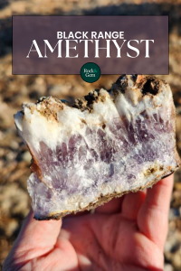
Is finding amethyst in New Mexico part of your rockhounding list? The northern Black Range in Catron County is a promising site for rockhounds to discover amethyst in the wild and is one of the few easily accessible places for finding amethyst crystals on public land.
Finding amethyst in the northern Black Range in southern Catron County, New Mexico, offers an accessible collecting local approximately a half mile north of the border with Sierra County. The locality is a former mining prospect on a hilltop. Amethyst is found within a trench and adjacent rocks excavated from the trench. The locality is within Gila National Forest, and it is easily reached by parking along NM-59 and a short hike.
Whether you’re an experienced collector or a curious beginner, this guide provides everything you need to know for a successful amethyst-hunting adventure.
What Is Amethyst? (And Why Rockhounds Love It)
Amethyst is the purple variety of quartz. Deep violet and dark purple rocks are among the most prized varieties. It has been known as a gemstone since ancient times. Pliny the Elder, the Roman Naturalist from the First Century, described the color of amethyst as being near to wine, but not quite that of wine. The name is said to be from the Greek word “Amethustos,” which translates to “not drunken.” Amethyst was said to have the power to prevent drunkenness.
Amethyst hues range from deep purple to bluish violet to light pink. The chemical formula is silica dioxide, or SiO2, and purple is from trace amounts of iron or other impurities in the crystal lattice. Radioactivity can also affect the color of amethyst. Buyers should be aware of the potential for artificial enhancements to amethyst.
How Amethyst Forms in the Black Range
Hydrothermal veins in volcanic rocks can have amethyst under the right conditions. Silica and other metals often enrich the hydrothermal fluids. As the fluids cool, the silica comes out of solution and crystallizes. Veins often have gases under extreme pressure during formation, and crystals can grow in the spaces occupied by gases. Under the right conditions, amethyst can form during crystallization. Some veins have trace amethyst, while others have abundant amethyst.
Amethyst that forms as a secondary mineral in sedimentary rocks is rare, and typically does not have the strong purple color of amethyst with a hydrothermal origin.
Where Amethyst Is Found Worldwide
Most amethyst mined today comes from Brazil and Uruguay. Many of the huge amethyst geodes that are seen at mineral shows around the world are from giant vugs in basalt from Minas Gerais in Brazil. Amethyst is also mined in Canada. In the United States, amethyst is found in Arizona, Texas, North Carolina, Pennsylvania, Maine, Colorado and New Mexico.
Exploring the Black Range: Terrain
The Black Range is a north-south trending mountain range in southwestern New Mexico. The north axis is along the border between Sierra and Grant Counties, and the northern section crosses into Catron County. Forest-covered mountains often appear darker than the surrounding lowlands, so the name “Black Range” is common for mountain ranges worldwide. The Black Range in New Mexico is west of the Rio Grande, so travelers heading north or south through the Rio Grande Valley see the Black Range get darker as the day progresses and the mountains become silhouetted by the sun.
Exploring the Black Range: History
Historically, the range took on the name Sierra Diablo, or the Devil’s Mountains. This was no joke, as the mountains were extremely dangerous. Apache raids, attacks by bears and mountain lions, and remoteness were major threats to miners and settlers during the mid-late 19th century. The canyons were steep and hard to access and had few clearings or meadows.
Exploring the Black Range: Geology
The Black Range is almost entirely Tertiary-age volcanic rocks with occasional isolated sections of limestone or other sedimentary rocks. The Black Range has many mines and prospects, and these are summarized in “The Geology and Ore Deposits of Sierra County, New Mexico”, which is Bulletin 10 of the New Mexico Bureau of Mines and Mineral Resources https://geoinfo.nmt.edu/publications/monographs/bulletins/10/.
Much of the Black Range is within the Gila National Forest, and many of the areas outside the forest are administered by the U.S. Bureau of Land Management (BLM). There are also privately owned parcels on public land. Many are former mining claims that were later patented, which meant that the original mining claim was now private land. Patented claims generally appear as irregular parallelograms or rectangles on maps that show public and private ownership. These may or may not be posted against trespassing and it is often difficult to see the boundaries between private and public land in the field.
Finding Amethyst: Initial Explorations
I have explored the Black Range since the early 1980s, when I was an exploration geologist with the Minerals Group with Superior Oil. I later traveled back to the mountains to explore mines throughout the district. The Black Range is still every bit as rugged and intimidating as it was nearly 40 years ago. While the central interior of the Black Range is quite rugged and difficult to access, the northern and southern sides can be reached relatively easily from Interstate 25 via Highways 52 and 152.
The only way to access many of the mines is up rugged roads in the stream canyons, which are generally dry. Back in the 1980s and early 1990s, many of these canyons were accessible, and I was able to drive up some of them to the point where the roads all but disappeared, and I had to hike. One of my most productive trips was up Poverty Creek, which drains the northern section of the Phillipsburg area. I found lots of large vuggy rocks with white quartz and amethyst crystals in this area.
Finding Amethyst: Poverty Creek
Unfortunately, the access roads and trails to Poverty Creek and many of the other canyons in the foothills of the Black Range cross private land. Since the early 2000s, I have found that many landowners lock the gates on the roads to public land, and this makes accessing many sites all but impossible. The last time I tried to access Poverty Creek, the gate was locked. The best way to get to mines in the Black Range is to follow the roads that still can access the Gila Forest Land or BLM land without going onto private land.
Since I had success at Poverty Creek and could no longer take this route, I looked for other nearby mines. According to Mindat. org, amethyst is reported to occur in veins at the Great Republic and Minnehaha mines, and these are marked on the USGS topographic maps for the Iron Mountain Quadrangle for 1999, available for review at https://mapstore.mytopo.com/ or at ArcGIS.com. If you access these maps, be sure to look at the maps produced before 2009, as cultural features such as mines and buildings are no longer shown on USGS topographic maps.
Accessing the Amethyst Site from NM-59
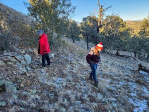
We went exploring for amethyst again in the Black Range in late 2023. Our group was five people, which included my wife, son, daughter and sister-in-law. Given the time and distance, we wanted a successful trip.
I decided to focus our efforts where we could likely get access. There is an access road to the Great Republic and Minnehaha Mines from Highway 59, but the topographic maps indicated that these are patented claims. We still decided to check if they were accessible. The road soon became too rough for driving, and we parked in a clearing. We then walked up the road and were soon confronted by a locked gate. At that point, we stopped and went back to our truck.
Fortunately, I anticipated access issues, so I had alternate plans. There is an additional prospect and shaft on the north side of Highway 59 on National Forest land. This is the Webber Mine, which is marked with a shaft and an unnamed prospect. The geology appeared similar, so these could also contain amethyst. This is shown on the topographic map as the Fluorine area.
FAQ: Finding Amethyst in New MexicoQ: Where can I find amethyst in New Mexico? A: The northern Black Range in Catron County is a prime location for finding amethyst, especially near NM-59 on National Forest land. Q: Do I need a permit to collect amethyst? A: Casual collecting is typically allowed on BLM and Forest Service land, but always check local regulations and avoid active or patented mining claims. Q: Can I access the site without four-wheel drive? A: Yes. The trench site is reachable by two-wheel drive vehicles. Just be sure to bring extra supplies, as the area is remote. |
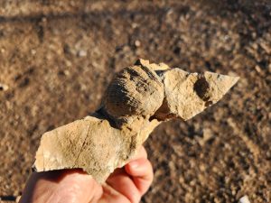
We drove about 0.9 miles further west on Highway 59 and parked at a large turnout on the south side of the road, and we were on National Forest land. We commenced an overland hike north to the Webber mine. The terrain was steep, but the hillside was free of underbrush, and it was a relatively easy hike. We crossed an area with limestone bedrock, and my son found a large brachiopod on the surface. This was an excellent fossil, but we still needed to find the mine and prospects.
We soon came up to the top of the hill. While finding amethyst, we scanned the ground for mine dumps or other features that would indicate prospecting or mining activity. We came across a broad trench that was man-made. It was in volcanic rock and had broken sections of quartz veins. Some of these had white quartz crystals but no obvious amethyst. I interpreted this as the Webber mine, but it was a trench and not a shaft.
Rockhounding at the Trench: What to Expect
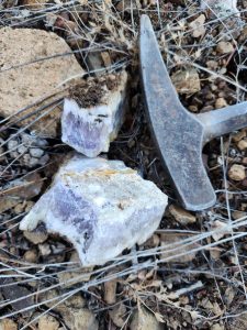
I found a fist-sized piece of vein quartz with crystals and broke this apart to see the interior. The broken surfaces revealed light purple quartz. This was amethyst, and further checking would likely reveal more pieces.
We looked in the trench, but it seemed like it had been picked clean of amethyst. Other rockhounds had been at this site based on the rock piles of white quartz. We found good pieces of terminated quartz crystals in the trench, but not much amethyst.
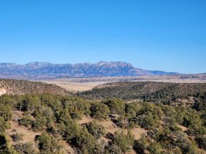
The trench material had been excavated and dumped east of the trench. This area was near the top of the hill, and it offered an excellent view of the San Mateo Mountains in the distance. We walked downslope and found loose pieces of light purple amethyst on the hillside. I poked in the ground with my rock hammer and found abundant loose rocks beneath the surface. Many of them were vein quartz.
Tips for Successfully Finding Amethyst Crystals
|
I cracked these open with my hammer, and the interiors were light purple. Several pieces had terminated quartz crystals. The cores were amethyst, and they graded into white quartz. This was contrasted with amethyst specimens at mineral shows that have cores of white quartz that grade into amethyst.
The best way to find amethyst was to explore the excavated material that had been pushed over the east side of the hill below the trench. White rocks protruding from the ground were generally from quartz veins and cracking them open often revealed purple cores or amethyst.
I later viewed this area on Google Earth and saw that there is a road just east of the trench area on the north side of NM-59. We did not see this during our visit, but it may be easier to use this road for access rather than walking overland to the trench. We also did not see any indications that this was an active claim.
Amethyst Site Coordinates
The amethyst locality can be reached with a two-wheel drive vehicle. From Interstate 25 near Truth or Consequences, take Exit 83 to NM-181/NM-52, and proceed 2.4 miles to NM-52. Head west of Highway 52 and proceed 45.4 miles to NM-59. Take NM-59 5.3 miles to the parking area, which is on the left (south) side of NM-59. Park here and hike up the hill to the trench.
The following are GPS coordinates from Google Maps:
- Parking area: 33°28’51.3”N 107°45’24.1” W
- Trench: 33°28’59.3”N 107°45’32.9” W Be sure to leave Truth or Consequences with a full tank of gas, water and food, as the area is remote. Gas is reportedly available in Chloride, but it’s best not to take chances. This is one of the few sites you can access in the Black Range without 4WD.
Final Thoughts on Finding Amethyst in the Black Range
Finding amethyst in the northern Black Range is one of the rare opportunities in New Mexico where beautiful crystals can be collected with reasonable access. With a little preparation and respect for the land, this rugged volcanic landscape offers a rewarding experience for rockhounds of all levels.
This article about finding amethyst in the Black Range previously appeared in Rock & Gem magazine. Story and photos by Robert Beard. Click here to subscribe.


