
The Alaska Ring of Fire is one of the most geologically dynamic regions on Earth, defined by more than 130 volcanoes—over 90 of which have erupted in the past 10,000 years, and more than 50 since 1760. Shaped by powerful tectonic forces, this arc of volcanic and seismic activity regularly makes headlines as craters smolder and earthquakes shake the landscape with little warning.
From the Aleutian Islands to Alaska’s southeastern panhandle, this land is a geological treasure trove. In the Alaska Ring of Fire, past eruptions, subduction-zone quakes, tsunamis, and dramatic mountain-building events have sculpted the landscape of this region unlike any other. In this article, we’ll explore the explosive geologic story of Alaska—one that continues to evolve beneath the feet of its residents and travelers alike.
From Land Bridge to Statehood: Alaska’s Origins
One theory as to how North America became populated with humans goes back to 1590 and the possibility of a land bridge between Asia and North America. Peter the Great, Russian Czar from 1682 to 1725, enlisted Danish explorer Vitus Bering to explore the Eastern regions of Russia in what’s now known as the Bering Sea. Two voyages later, Bering confirmed that there was land across the water and that people living there had been trading goods and traveling across the Bering Sea for thousands of years.
In 1778, Captain James Cook’s expedition produced detailed maps of the region and news of his travels brought the land bridge theory to the rest of the world. But it was a geologist, David M. Hopkins, who accepted a position with the U.S. Geological Society in 1942, and whose passion for the subject brought scientists and researchers from several disciplines together to create the Bering Land Bridge National Preserve initiative.
Alaska was a Russian territory until it was purchased by the United States in 1867 for $7.2 million. Only 2,000 people were thought to live in this vast territory at that time. The land remained a U.S. Territory until becoming the 49th state on January 3, 1958. By that time, the population had grown to 224,000.
Volcanoes of the Alaska Ring of Fire
Out of Alaska’s 130 volcanoes, over 60 dormant and active volcanoes make up the string of the Aleutian Islands that stretch from the mainland of Alaska to Russia. The next largest number is located in the panhandle and only a few are found in the interior of the state.
For comparison, the entire Pacific Ring of Fire, which encircles the Pacific Ocean pole to pole, is made up of between 700 to 900 dormant and active volcanoes, depending on the regions included.
Unimak Island, in the eastern Aleutians, is home to six active volcanoes. Mount Shishaldin, the highest at 9,373 feet above sea level, is one of the most active in the Aleutian chain with 40 eruptions in the last 11,700 years, the latest in 1999.
The Aleutian Arc was formed around 55 million years ago during the early Eocene period. These volcanoes formed because of the subduction of the Pacific plate beneath the North American plate along 2,100 miles of the Aleutian trench, making up the northern arc of the Pacific Ring of Fire.
Subduction, very simply, is a geologic process that occurs when two tectonic plates converge, and the heavier plate forces itself beneath the other plate and sinks into the Earth’s mantle. The place where this process occurs is called the subduction zone. Earthquakes are common along subduction zones as well as volcanism in the upper plate, when hot fluids and magma are released by the subducting plate.
Subduction along the Aleutian Trench continues today at a 45-degree angle, at a rate of three inches a year. As a result of this constant tectonic activity, thousands of earthquakes occur here each year, making it one of the most seismically active areas in the United States.
Two Disasters That Shaped Alaska
Two past geologic events proved to be catastrophic to the Alaskan landscape and its residents. The first event happened on June 6, 1912. Fortunately, there was no loss of life when Novarupta volcano erupted. Frequent earthquakes preceding this eruption prompted the early evacuation of nearby towns and villages.
Novarupta, in the Katmai cluster of eight volcanoes, is located 290 miles southwest of Anchorage. This eruption blew an ash cloud 100,000 feet (20 miles) high and released three cubic miles of magma, 30 times more magma than Mount St. Helens in 1980. It was categorized as a 7VEI (Volcanic Explosive Index) super volcano—the most severe rating.
The second occurred on March 27, 1964, the Good Friday earthquake. This event was a 9.2 magnitude earthquake across south-central Alaska that caused ground fissures, tsunamis and landslides, resulting in over 139 deaths and extensive damage. Five people died as far away as Oregon and tsunami waves were reported in over 20 countries. Property damage was estimated at $116M ($871M in 2023 dollars).
Recent Eruptions in the Aleutian Arc
Recently, there have been several smaller-scale eruptions in the vicinity of Dutch Harbor on the island of Unalaska. On January 30, 1995, the Makushin volcano sent an 8,000-foot plume of ash into the sky. It is a stratovolcano rising 6,680 feet above sea level. As recently as February 2025, steam was visible escaping from its crater.
Bogoslof Island, about 35 miles northwest of Unalaska Island, is home to a Sea Lion sanctuary. On this small island, only 319 acres, Bogoslof volcano resides mostly below sea level. An eruption in 1992 registered a 3VEI. Another eruption on December 21, 2016, sent a plume of ash nearly 32,000 feet in the air, but it only lasted about an hour. Bogoslof volcano continued to show signs of activity in 2017 and 2019.
World War II’s Mark on the Aleutians
During WWII, Hawaii and Alaska were still U.S. Territories, but both suffered bombing attacks by the Japanese. Japan planned to occupy the Aleutian Islands to make an attack by the U.S. more difficult. The islands of Attu and Kiska in the Aleutians were occupied by Japan from 1942-1943. And on June 3, 1942, Japan bombed the village as well as the U.S. Army and Navy bases of Dutch Harbor.
Before the war, about half of the inhabitants of the Aleutian Islands were native Aleut, the Unangax people. During WWII, these Native Americans were caught in the crosshairs even though they were U.S. citizens. Some, in the occupied islands, were taken to Japan as prisoners of war, while others, including 138 Aleut natives from Dutch Harbor, were forcibly relocated within Alaska and other parts of the United States.
Most of these refugees were housed in old, derelict buildings. Without proper food, housing and medical care, many died. Aſter the war, some of these refugees returned to their Aleutian homes.
On a visit to Dutch Harbor in the Alaska Ring of Fire in June of 2024, our tour guide told the story of her mother-in-law, Mary (“Maria”) Chagin, who was one of the children and their families, displaced by the war. A young child at the time of the evacuation, Mary was lucky to return to her home in Dutch Harbor aſter the war, marry and raise a family. Her son, Dennis Robinson and his wife, Lynda Lybeck-Robinson, were our hosts while touring their island. Lynda is also an avid photographer and contributed several of the photos included in this article.
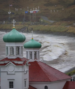
Today, gunnery bunkers still dot the landscape of Unalaska, along with a WWII cemetery and memorial, a WWII museum and a Russian Orthodox church.
Alaska Ring of Fire: Current Volcanic Threats
The Pacific Ring of Fire continues to show signs of heightened activity. From lava flows in Hawaii to strong earthquakes across Asia, seismic volatility spans the ocean’s rim. Most recently, on July 29, 2025, a magnitude 8.8 earthquake struck off Russia’s Kamchatka Peninsula, spawning Pacific-wide tsunami alerts that were later lifted after authorities determined the threat had passed, a stark reminder of how quickly these natural events can escalate and affect communities thousands of miles away.
Alaska, sitting along the northern arc of the Ring of Fire, remains one of the most seismically active regions in the United States. Earlier this year, the village of Adak—located midway between Unalaska and Attu—experienced a cluster of tremors, with at least eight quakes exceeding magnitude five in a single week. The consistent rumbling across the Aleutian Arc signals the ongoing tectonic pressures deep beneath the surface.
In 1964, when a magnitude 9.2 earthquake devastated parts of Alaska, the state’s population was around 263,000. Today, that number has grown to over 733,000, with most residents concentrated in Anchorage, Juneau, and Fairbanks—putting more people at risk should another major geologic event occur.
Fortunately, scientists now monitor Alaska’s volcanoes and fault lines along the Alaska Ring of Fire using advanced seismic tools and satellite imaging. Early warning systems are in place to alert communities of potential danger. However, Alaska’s rugged terrain and limited infrastructure still make emergency response and evacuation challenging, especially in remote areas.
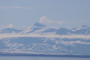
Several volcanoes are currently under close observation. Mount Spurr, located just 75 miles west of Anchorage and within reach of two-fifths of Alaska’s population, has shown increased activity in recent months. In early 2025, the Anchorage area experienced over 100 earthquakes per week, and gas emissions from Spurr’s crater have intensified—leading scientists to raise concerns about a possible eruption.
Mount Spurr last erupted in 1953 and again in 1992, both brief events that sent ash clouds drifting hundreds of miles. But experts caution that future eruptions could be more disruptive, especially given the volcano’s proximity to urban centers. In this volatile landscape, time will tell for the volcanoes and the people living in the northern arc of the Alaska Ring of Fire.
This story about the Alaska Ring of Fire previously appeared in Rock & Gem magazine. Story by Sue Eyre. Click here to subscribe.


