
By Helen Serras-Herman
In the rolling hills of the high desert of Northern Arizona, about 85 miles north of Phoenix and 12 miles east of Prescott, the valley of the Agua Fria River is nestled next to the Bradshaw Mountains, and the Prescott National Forest. It is an area rich in history, dating back to the Native American people who originally lived there, then Spanish explorers who arrived in the 1500s, and finally, the settlers and miners that came in the 1800s.
Two Become One
Once two distinct communities, Dewey and Humboldt became one town after a voters’ supported incorporation in 2004. Today the town is known as Dewey-Humboldt. While the Dewey area provided agricultural and ranching economy, Humboldt’s prosperity was based on mining. The communities are located in Yavapai County, which sits at an elevation of 4,556 feet, with a mild four-season climate, and at one time home to more than 1,500 mines listed.
Back in 2014, my husband and I enjoyed a backcountry tour of the mining areas of the Bradshaw Mountains, with tour guide Kevin Leonard, a local miner and historian. We also visited the Dewey-Humboldt Museum, which is located in the heart of the town’s historic district. The museum is supported by the Dewey-Humboldt Historical Society, and exhibited mining tools and equipment, testing and assaying equipment from the Iron King Mine assay office, and a small mineral collection.
We visited the museum again in 2016, but like so many mines and historic locations in Arizona, when we stopped by this past August of 2019, on our way to the Prescott Gem & Mineral Show, things had changed. The building that once housed the museum is now a private residence, with a no-trespassing sign on the property. Upon inquiring about the museum at the local gift shop, we learned that the museum lost its lease and the building was sold, and the contents of the museum, including the collection, are packed away.
We also learned of the passing of our tour guide, Kevin Leonard, in September of 2018.
Nevertheless, in these bleak moments, two bequeaths made by members of the historical society who also passed away recently, are supporting the rebirth of the museum. A lot was purchased and the new museum is being planned.
Uncommon View
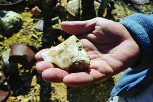
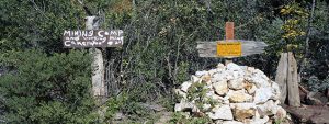
The Humboldt District Mining tours were truly unique adventures, enjoyed from the seat of a 4-wheel pickup truck, progressing through some incredible locations. We drove over some “roads”- no, hold on, washes with huge boulders, which are “roads” I never thought we could drive or even walk on. When the truck could proceed no further, we walked up dry washes. We crossed mountains, gulches, and streams, and visited forgotten mining camps, and mines that brought wealth to mine owners and investors. Some of the mines still have visible traces of gold, silver, and copper on their walls.
During this same tour, we drove on the Iron King Road and visited the old McCabe Cemetery and federal mining claims, such as the Silver Queen Mine with mining tunnels, and the Union Mine that has a tunnel with beautiful stalactites hanging from the ceiling.
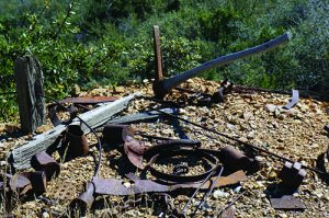
Laying about within these tunnels were old mining tools and rusted cans, remnants of the prospectors’ arduous life at mining camps.
The Dewey area was settled in 1863 after the discovery of gold on Lynx Creek by pioneer prospector King Woolsey (1832-1879). He founded the Agua Fria Ranch to supply the miners, and built a small quartz mill to work gold ores from nearby hills. In the mid-1870s, a small water-powered, silver-lead furnace, the Agua Fria Furnace, was built to work the ores of the nearby mining area. The area would later become the Iron King Mine.
An additional form of economic development, the Prescott & Eastern Railroad, was built in 1898 and connected Prescott to Mayer to the south, and the Val Verde Smelter in Humboldt. After the smelter burnt to the ground in 1902, a larger smelting plant was built, serving much of the then Arizona Territory. In 1905, the town was renamed Humboldt, in honor of Alexander Von Humboldt, a noted Prussian geographer, who had visited the area (New Spain at the time) in 1838. The rich ores, along with the smelter and the convenience of the railroad, contributed to the district’s mining boom and population growth.
When visiting Humboldt today, the smelter’s smokestack stands alone, casting its shadow over the century-old town buildings. It is a remnant and reminder of the region’s mining history.
The Blue Bell Mine, located south of Mayer, was one of the most productive mines within the Bradshaw Mountains during the World War I era. At the time, mineral prices were high and the mine had a direct connection with the smelter via railway. However, the prosperity was short-lived, and the mining boom came to an end with the 1929 financial crash. The mines and smelter closed but re-opened in 1934. The nearby Iron King mine then became the most productive mine in the Bradshaws, producing $100 million in gold, silver, lead and zinc, until its permanent closure in 1968 (Robert L. Spude, Central Arizona Ghost Towns, Las Vegas Nevada Publications, 1978).
Incidentally, the Bradshaw Mountains are named after William D. Bradshaw of North Carolina, an engineer who came to the area as a prospector during the 1863 Walker expedition at Lynx Creek.
Eyeing Future Exploration
The Dewey-Humboldt Historical Society (http://www.deweyhumboldthistoricalsociety.org/) occasionally leads tours to some of the area’s abandoned and forgotten mining camps and Native American ruins. I do hope that someone can revive Leonard’s mining history tours on a more regular basis, and offer visitors a glimpse of the past, and an understanding of the hardships that miners endured and the fleeting rewards they received.
The future site of the Dewey-Humboldt Historical Society Museum
will be conveniently located along Arizona Route 69, about 1/10 of a mile north of the intersection with Main Street in Dewey-Humboldt, as the President of the DHHS, David Nystrom, kindly shared with me. I truly look forward to returning and visiting the new museum and reporting back to all of you.


