
Shonkin Sag is one of Montana’s most dramatic but often overlooked geological features. This massive dry channel, carved during the Ice Age, stretches more than 60 miles across the Highwood Mountains. Near the town of Shonkin, its volcanic laccoliths and the striking Lost Lake remind us how fire, ice, and water combined to shape the region’s unique geology.
Exploring Lost Lake and the Shonkin Sag
Pulling alongside the dirt road in the heart of the Highwood Mountains of Central Montana, our mission was to finally visit Lost Lake, a geological spectacle I’ve heard about for the dozen years I lived in the area, but never made the trek to see it. Even my husband, Grant, who grew up here, never saw it, so we didn’t know what to expect.
Following dirt roads that would turn to gumbo at the slightest rain, Grant was familiar with much of the area from his years in the woods, but it still took careful navigation to find the spot on private land. At that time, a sign directing us not to drive beyond a certain point indicated we were in the right spot, even though all we could see were dark, hoodoo-looking rocks along the landscape.
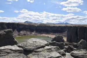
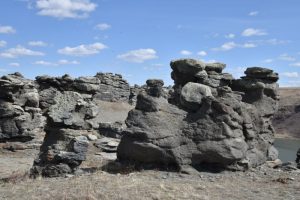
Hopping out of the truck, we walked less than a quarter-mile to the edge where an ancient waterfall, twice as tall as Niagara Falls and a half-mile wide, yet now long dry, stood as a reminder of the powerful forces that shaped this landscape. Vertical shonkinite laccoliths gave the appearance of a castle fortress. Even in April, before the spring green-up, it was breathtaking. Welcome to the workings of the Shonkin Sag.
Shonkin Sag and Glacial Lakes in Montana
“Everybody knows about Glacial Lake Missoula, but the Shonkin Sag doesn’t get much attention,” explained Rod Benson, the best earth science teacher any student is fortunate to have, along with an avid hiker who packs along genuine scientific curiosity on every trip. Benson said teaching freshman earth science for over 25 years allowed him the opportunity to focus on the unique landscape we have in Montana. He continues to instruct students in Hays, Montana, and often leads the students on field trips to study these features in the real world.
Like Glacial Lake Missoula, Glacial Lake Great Falls covered an enormous expanse beginning near Great Falls and reaching nearly 80 miles south to the Helena Valley. Benson said that where the Cascade County Courthouse stands in downtown Great Falls was once covered with 500 feet of water. This also means that Gore Hill, which is 300 feet above town and where I live, still would have been a couple of hundred feet below the surface. This makes sense considering the layers of shale not very far under the soil in our yard, which makes planting trees problematic.
Volcanic Geology of the Shonkin Sag Region
But the story of the Shonkin Sag actually began long before Glacial Lake Great Falls covered the region. “There was an episode of vulcanism that formed the Highwood Mountains about 50 million years ago,” Benson explained. “Most of the mountains in central Montana are due to volcanism.”
Although it’s difficult to initially distinguish with the thick vegetation, the Highwood Mountains are remnants of an ancient volcano, albeit eroded after tens of millions of years, and evidence of this fiery creation marks the landscape.
There are many buttes, particularly Square Butte and Round Butte, where the magma didn’t erupt through a volcano, but instead was pushed up from below, creating dramatic vertical laccoliths. Benson noted that “laccolith” means “lake of rock,” and these are commonly associated with the volcanic activity in this region.
How Ice Age Floods Shaped the Shonkin Sag
While fire created the mountains, water shaped them, even when it was frozen. “Once every 100 thousand years, we’ve had an ice age,” Benson said. “The Pleistocene Epoch (an ice age) started 2.7 million years ago and lasted up until 10 to 12 thousand years ago.”
During this era, the Laurentide Ice Sheet crept down as far as north of Great Falls, near the current Fort Benton and Big Sandy, blocking the historical flow of what is now the Missouri River, which at that time traveled northeast toward Havre as it made its way to Hudson Bay. The ice pinched off the flow to the north and pushed the river to the east, causing the water to squeeze between the ice sheet and along the northern base of the Highwood Mountains. As it found a new path, it carved a channel through softer ground along the volcanic rock.
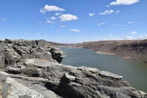
This now dry channel of the ice age path of the Missouri River is what we call the Shonkin Sag. Stretching over 60 miles long from the town of Highwood to just east of Geraldine, the “Sag” was approximately one and a half miles wide and up to 300 feet deep.
This enormous push of water made its mark, but exactly how it happened leaves room for speculation. For many years, geologists believed it was caused by a catastrophic release of an ice dam, such as the one that occurred with Glacial Lake Missoula, that reached the Pacific Ocean, changing the landscape along the way. Others believe it wasn’t necessarily a sudden, single event.
Geologic Theories of Shonkin Sag Formation
“It’s kind of complicated,” explained Benson. It’s difficult for us to wrap our heads around processes that occurred millions of years ago and not to paint a simplistic picture. Mother Nature works by her own means, and nothing in nature is static.
When we think about it, it makes sense that seasonal melting most likely occurred during the warmer months during this time, adding additional water into Glacial Lake Great Falls, along with the diverted river channel. As the Earth warmed between 10 and 12 thousand years ago, the amount of water flowing into the system most likely increased, thereby increasing the water in the system.
Gerald Davidson, a retired research physicist who happened to graduate from Harlem High School, the same Montana school as Benson, albeit a couple of decades earlier, spent a considerable amount of time and effort studying the geology of the region. Benson said, “His hypothesis is the Shonkin Sag is not as simple as one outburst flood, but multiple outburst floods.”
He said that there was possibly a narrow opening that pinched the flow and built up water before a sudden release. This happened time and time again. The water eroded the landscape by its consistent flow through the main channel, as well as through a series of dramatic events.
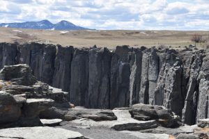
Lost Lake Shonkin Sag and Its Dry Falls
This is how Lost Lake most likely came into being. When looking at an aerial map, it’s obvious that the lake was not part of the main channel but created as a side route. As the river filled, these alternate tributaries carved paths, including the stunning 300-foot-high cliff of what is called the “Dry Falls” of Lost Lake.
Numerous alkali lakes dot the landscape along the Shonkin Sag, but Lost Lake is one of the most visible reminders of this grand water channel. Although Lost Lake is on private land, for decades the land owner allowed visitors to stop and peer over the side into the now shallow water. Unfortunately, after being inundated with people, especially those who vandalized the rocks and left trash during the pandemic, it’s no longer accessible to the public. Many people would love to see it as a state park, but nothing is in the works at this time.
Square Butte and Other Shonkin Sag Landmarks
Farther to the east, there is an equally impressive cut bank resulting from the ancient water channel eroding along the laccoliths near Square Butte. Even though Square Butte is on private land, MT Hwy 80 travels past the site and offers a glimpse of the cliff of vertical laccoliths when you travel northwest from the town of Square Butte.
The Lasting Legacy of Montana’s Shonkin Sag
With vegetation growing where water used to flow, the once grand channel of the Shonkin Sag looks more like another one of the sweeping valleys that shape our landscape. We gain a glimpse of remnants of its grandeur and land-altering power at places such as Lost Lake or the laccoliths near Square Butte, and end up with a better understanding of how fire and ice worked together to create this beautiful area.
This story about the Shonkin Sag previously appeared in Rock & Gem magazine. Click here to subscribe. Story and photos by Amy Grisak.


