
If you’re wondering how to find evidence of an ice age, look all around you. Most everyone is familiar with the concept of the Ice Age, especially with the popular movie franchise. There was not, however, just one ice age and glaciers are not a thing of the past. There is plenty of evidence of these events all around for the rockhound, hobbyist or anyone with any curiosity about the world around them.
Evidence of an Ice Age
What most people refer to when using the term Ice Age, is the most recent period when global temperatures were much colder than now and a significant portion of the earth was covered in ice sheets and glaciers.
There is great debate among climate scientists over how many ice ages have occurred over Earth’s history. We are sure of at least five major ones, but there could have been as many as 40 ice ages over time. The most recent ice age ended about 11,000 years ago. The average global temperature was at least 10 degrees colder than today, though regionally specific areas were 40°F to 50°F colder than they are now. Ice ages are caused by a variety of conditions including changes in Earth’s atmosphere like wind and ocean circulation, volcanic activity, and greenhouse gas levels. Plate tectonics as well as the cyclical nature of Earth’s orbit and axis have all contributed to the onset and conclusion of various historic ice ages.
James St. John is licensed under CC BY 2.0.
How Do We Know There Were Ice Ages?
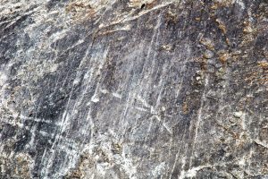
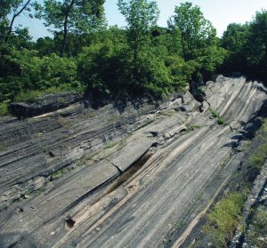
There are several types of evidence that scientists use to base their determinations regarding the existence of ice ages. Geological evidence is often the easiest to find and study. This can include the examination of scratches and marks in rock, the sculpting of the landscape into valleys, knolls, drumlins, and the like, as well as looking at the remnants of what glaciers leave behind. These “leavings” are grouped into moraines, glacial till, and glacial erratics. When geological evidence is not sufficient, researchers also look at paleontological and chemical evidence.
The existence of various fossil types and their relative placement can be used to determine whether organisms that would have been adapted to cold climates or those that preferred warm climates, were around at the time of the glaciers. This of course requires that fossils are available to be found. Chemical evidence includes an examination of isotopes and their ratios in sediment, rocks, and cores. This allows for the creation of a temperature record since the weight of isotopes is relative to the temperature when they occurred. The easiest evidence to evaluate is the geological clues that glaciers have left behind.
What is a Moraine?
Moraines are accumulations of sediment, soil, and rock deposited by glaciers. They can be miles long and influence the landscape throughout the continent. Materials both large and small are found in moraines and mixed together with no evidence of the type of sorting that happens with water flowing through it.
By KatmaiNPS is marked with Public Domain Mark 1.0.
Ground Moraines
Ground moraines are the most common and occur all over the world. They are predominantly made up of clay and sand deposited in irregular patterns in the wake of melting glaciers. These “pockets” of sediment can blanket the bedrock with depths of over 50 feet. On the surface, these moraines may just appear as rolling hills, knolls, or other built-up but smooth land features, usually covered in vegetation. There are four main types of ground moraines—lateral, medial, supraglacial, and terminal—with several subtypes. Many moraines are simultaneously more than one type as they were not always formed by a single event.
1. Lateral moraines form on the glacier’s sides while it scrapes along the landscape. The collected material is then deposited on either side of the receding glacier. Often valleys are flanked by matching ridges of similar materials and size that are not like the bedrock they sit atop.
2. Medial moraines are found on and within existing glaciers, as well as in their path. This type of moraine is the result of two glaciers meeting and merging, causing what were lateral moraines, into a single line of rock and sediment in the middle of the conjoined glaciers. As this bigger glacier begins to melt, the medial moraine left behind will be a single ridge in the middle of a valley.
3. Supraglacial moraines are formed from the sediment on the surface of glaciers. Once the glacier melts, the debris left behind forms a more evenly distributed moraine than other types. Lateral and medial moraines can be supraglacial depending on how they were formed.
4. Terminal, or end moraines are formed when all of the sediment and rock that had been collected by a glacier, is deposited into a single pile. It is usually found as ridges across the valley floor, formed at the tail of a moving glacier. Terminal moraines are useful for researchers to determine how quickly a glacier moved across an area. The rocks and minerals in the moraine show where the glacier traveled. Those formed by the bulldozer-like action of the advancing glacier are called “push” moraines. Moraines formed when the advancing glacier remains in a location over time leaving a cross-valley ridge are called “recessional” moraines.
Moraines can be further designated by distinct characteristics. Moraines formed when stagnant glaciers melted and have left an irregularly shaped layer of rock and sediment on the former bed of the glacier are called ablation moraines. Moraines that form over the surface of an existing glacier that is still frozen, but stagnant, are called ice-cored moraines. Other remnants of glaciation include glacial till and glacial erratics.
By brewbooks is licensed under CC BY-SA 2.0.
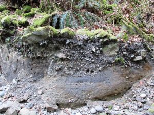
Glacial Till
When rock and sediment are deposited by a river, they are usually sorted by size. Larger rocks are deposited first and so on. When rock and sediment of all sizes are found together, it is generally the work of a glacier that deposited all of its contents when it melted or moved. This is known as glacial till. Finding several rocks of varying sizes together is not necessarily evidence of glaciation. When glacial till is found, there are sediments and rocks present from particles smaller than a grain of sand, all the way up to boulders. Glaciers grind rocks as they pass over them, resulting in this size range. Till that is deposited by moving glaciers, as opposed to melting ones, is called lodgement till. The tiniest of the sediment, which is silt or colloids, is sometimes referred to as glacial flour. This term is generally reserved for the sediment released by actively melting glaciers and the cloudy-colored water in the streams and lakes that are downstream. Glacial flour can be the source of brightly colored sparkles reflecting sunlight in shallow bodies of water.
By James St. John is licensed under CC BY 2.0.
Glacial Erratics
Glacial erratics are rocks of any size that have been transported from one area and deposited in an area where they are out of place compared with the bedrock or other sediment where they were found. Erratics help to tell the tale of a glacier’s travels. They were picked up (entrained) by a moving glacier or iceberg, carried across miles and miles of land and left behind when the ice they were bound in melted. Erratics can be smaller than a pebble, up to the size of a large boulder. The larger they are, the easier to spot them. They could be the lone erratic in a location or one of dozens or more found in a single outcropping.
Erratics are useful in mapping the trajectory of glaciers. Granite boulders, for example, found among limestone bedrock can tell geologists the flow, type, and an estimated time when the glacier was last in that area. These rocks became part of the glacial conveyance by falling into the glacier, being scraped off the sides of mountains as the glacier passed, or picked up from the ground as it moved over top of them and trapped them in their icy mass. Rocks that traveled on the glacier’s surface are known as supraglacial. Those that were carried along the base of the glacier are referred to as subglacial.
5 Places to Find Evidence of an Ice Age
Here are some selected destinations in the U.S. to see evidence of an ice age…
1. Glacial Grooves State Park at Kelleys Island, Ohio, is the largest accessible glacial grooves in the world.
2. Glacier National Park in northwest Montana has glacial rivers, carved-out valleys, and melting glaciers as well as glacial erratics and other ice age evidence.
3. Big Cottonwood Canyon in Utah has glacial striations that can be seen around Lake Blanche.
4. The Ice Age Trail in Wisconsin is a 1,000-mile footpath with evidence of the last ice age throughout.
5. Shelburne Bay Park in Burlington, Vermont, is one of many examples of glacial activity throughout the state.
This story about evidence of an ice age appeared in Rock & Gem magazine. Click here to subscribe. Story by Chris Bond.


