
Story and Photos by Marc Davis
“Have you ever gone prospecting on the river along the Stevens Trail?” I asked fellow miner and acquaintance Mike. “Sure,” he replied. “Lots of times. There’s some good gold down there. Big gold.”
Big gold! This comment grabbed my attention. We kept chatting, and eventually I asked the inevitable question, the one that is rarely answered truthfully by miners who have discovered good gold: “So, just exactly where did you find this big gold?”
Mike came back with a straight answer. He explained that, as he follows the Stevens Trail down to the North Fork of the American River, he takes the first spur trail that is nearly as large and well used as the main trail that leads down to the water. Then he crosses to the far side of the river and prospects in the typical locations where gold is likely to accumulate. Gravel deposits on the downstream side of large boulders and bedrock crevices are characteristic of locations that have possibilities of providing some nice gold.
Mike also explained that he uses a sluice to run as much material as he can and does better with a sluice than with a gold pan. This was great information and I very much appreciated Mike being so candid as to share it with me.
Since the Stevens Trail is located near Colfax, in Northern California, and is within easy driving distance of my home, I had been considering it as a potential access point for a prospecting trip along the American River. I had been hesitant to start this adventure because of the length of the hike. It’s about a three-mile jaunt down into the American River Canyon, not so bad going down, but a lot of uphill on the way out. Still, there is a great deal of information both historically and geologically that indicate this location on the North Fork would likely produce some good gold.
Modern-day history books report that, during the California gold rush, thousands of miners toiled for gold in the American River Canyon, through which the North Fork runs. Accounts from gold-rush diarists such as E. Gould Buffem’s Six Months in the Gold Mines (circa 1847-49) and the diaries of John Banks and J. Elza Armstrong, published under the title The Buckeye Rovers in the Gold Rush (circa 1849-52), attest to the extent of mining activity and richness of the North Fork of the American. (Both are available in reprint.) The Feb. 10, 1850 entry taken from John Banks’ dairy reads, “Dixon and Ferrill have come over from the North Fork. Generally speaking men have done well, a few remarkably well. One man found a lump weighing 16 pounds.”
A reprint of Waldemar Lindgren’s study titled The Tertiary Gravels of the Sierra Nevada of California, originally printed in 1911 as a government publication for the Department of the Interior, U.S. Geological Survey, traces the pathways of ancient gold-bearing river channels. According to Lindgren, one of these ancient channels is the source of gold that was responsible for the rich hydraulic mines in Iowa Hill to the east and Dutch Flat to the north of the Stevens Trail and American River junction.
A chart in Lindgren’s report indicates this ancient channel crosses the modern-day North Fork of the American upstream from where the Stevens Trail encounters the river. It is speculated that gold eroding out of this ancient channel is the source of much gold in the North Fork today, some of which could make its way downstream to the Stevens Trail area.
This information, coupled with my friend Mike’s declaration that there is “big gold” on the North Fork, sealed the deal. I decided that—long hike or not—it was high time to capture some Stevens Trail gold.
The Stevens Trail has been in use for many years. It’s mentioned in several hiking guidebooks and is listed on the National Register of Historic Places (https://npgallery.nps.gov/nrhp). To search the NRHP site for information on Stevens Trail, type “Stevens Trail” into the Resource Name field. Select “California” from the State menu, and “Placer” from the County list. Press Enter and click on the Stevens Trail entry.

The history of the trail is quite interesting. According to information in the NRHP listing, the route of this pack trail was originally laid out by John Rutherford, and construction was completed by his partner, Truman Stevens, for whom the trail is named. Stevens completed the trail in 1871 and operated it as a toll route for foot traffic, horses, and pack mules traveling between the then-bustling mining town of Iowa Hill and the connection to the Transcontinental Railroad, in what is now the town of Colfax.
Early on, the trail included a suspension bridge across the American River, near Secret Ravine. The trail was used extensively from 1871 to 1895, and continued to be used on a fairly regular basis through 1906. Eventually, due to weathering and lack of repair, the bridge deteriorated. In 1914, it collapsed and was never rebuilt.
Despite the absence of the bridge, the trail remained in use to some degree for many years. Interest in the trail was revitalized in 1969, when Eagle Scout candidate Eric Kiel marked the trail. One of his signs remains in place today.
The section of the trail leading from Colfax to the North Fork of the American River is currently a popular hiking, mountain biking, and equestrian path. It is recorded in some trail guidebooks as being 4.5 miles long. However, the river can be reached in 3.2 miles by taking a spur trail down to the water’s edge before reaching the main trail crossing at Secret Ravine.
According to guidebooks and my own experience, the trail is not without its perils. It drops roughly 1,200 feet into the American River Canyon. This makes for a lot of uphill hiking on the way out after a long day of mining. Rocks and tree roots protrude from the path, creating trip hazards. There are precipitous drop-offs at the trail’s edge in more than one location.
Stream crossings are rocky and can be treacherous. In the summer, the trail is unshaded for much of its length, exposing hikers to blazing sun and extremely hot temperatures. Winter months in the area are rainy; trail conditions can deteriorate and become slick and muddy. Higher water levels make crossing the many streams that traverse the trail even more difficult. There is poison oak in some locations, and the possibility of encountering a rattlesnake, mountain lion, or bear is very real. Still, the trail remains quite popular and the trailhead parking lot can fill up during busy times of the year.

I decided to hike the Stevens Trail from the Colfax trailhead on a cool fall day, when temperatures would be relatively mild and the river would be running fairly low. Because of the length and difficulty of the hike, I limited my mining equipment to what I considered to be the minimum for a small-scale sluicing operation. I took a gold pan, a screen with ¾-inch mesh, a collapsible shovel, a hand trowel, a whisk broom, a crevice tool, a 4-gallon bucket, a small fluid bed sluice, some tweezers, and a poke filled with vials to hold the gold I hoped to find. It should be noted that the section of river I would be accessing is designated as Wild River in the Wild and Scenic River system. Any form of mechanized mining is not allowed, and the area is not open to claim staking.
Hiking the Stevens Trail is an adventure in itself. It traverses below the historic Cape Horn, a large rock precipice from which Chinese laborers reportedly suspended themselves in wicker baskets. High above the river canyon floor, they chipped and blasted away solid rock to construct a portion of the Central Pacific Railroad in the 1860s. There is a point of historical interest marker at the Colfax city limits on state Route 174 commemorating this engineering feat.
Continuing past Cape Horn, the trail passes a seasonal waterfall at Robbers Ravine. Farther on, there is an old mine adit bored into a sheer rock wall. Beyond the old mine, there are spectacular views of the American River Canyon, with the Mineral Bar Bridge off in the distance.
About three miles from the trailhead, there is a fork in the trail leading off to the right and down to the river. It was the first major spur I had come across that appeared to meet the description provided by my friend Mike. The spur trail is only about 0.2 mile in length, but it is steep and slippery near the bottom, just before it opens up onto a large bedrock outcropping adjacent to the river.
Exposed bedrock can be very beneficial to a small-scale miner because heavy gold will generally work its way down through lighter material until it hits a bedrock barrier and can go no farther. When the bedrock is exposed, it saves a miner the trouble of having to remove barren overburden in order to get to the rich material below. This bedrock looked particularly inviting, since it contained many crevices, shelves and potholes where gold could be hiding. I mentally kicked myself for not bringing a metal detector for checking the exposed crevices.
I took a look across the river and eyeballed a vast gravel bar that could provide rich material for sluicing. I pondered crossing to look for the big gold Mike spoke of, but the river was rather deep and running fast through a bedrock channel at this location. I scrambled my way across bedrock, going upstream for quite a distance. Still, I didn’t spot a decent crossing. Along the way, I continued to see bedrock formations with steep, sharp drop-offs and hidey holes where gold could be lurking. I also noticed a great location to set up my sluice. Consequently, I gave up on the idea of crossing the river and stayed on the near side to try my luck.

I set up my sluice and then evaluated various nearby bedrock formations that would create eddies in the river during high wintertime water flows. Eddies are where heavy material like gold drops out and gets trapped, waiting for a miner to come along and find it when the water is low. I spotted a number of sharp bedrock drop-offs that formed a shelf 2 or 3 feet lower and downstream of the adjacent bedrock surface, formations that would create such eddies. Cobbles and sand had collected on these shelves. My hope was that gold had dropped out here, too.
I broke out my mining tools and set to work removing the cobbles from on top of the deposit. I worked my way down to the smaller rocks and sand that should be my pay dirt. I shoveled this material onto a screen I had set on top of a bucket. When the bucket was about three-quarters full of screened pay dirt, I took it to the sluice and ran it through. I repeated this process until I was down to bedrock.
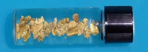
Then I cleaned the bedrock with a whisk broom and used a miner’s crevice tool to scrape material out of a crack in the bedrock that was revealed where the vertical and horizontal faces of rock came together. If there were any nuggets here, I figured this crevice was where they would be. I collected the material I had removed from the crevice along with the bedrock sweepings, placed them in the bucket, and ran this material through the sluice, as well. Then I cleaned out the sluice and panned the concentrates, revealing a number of really nice flakes of gold. Although I was hoping for nuggets, I was happy with the size and quantity of flakes recovered from this first effort.
After working a second, similar location and coming up with similar results, I had a decision to make: stay late and likely get more gold, or start the long uphill hike out. The hiking guidebooks I read recommended allowing three hours for the hike back from the end of the trail at Secret Ravine. My hike would be a bit shorter, but would still include a good deal of trudging uphill, so I decided to call it a day. I packed up my gear and started the long climb back to the parking lot with a smile on my face, knowing I picked up some nice gold.
Those who want to try their luck on the North Fork will find the trailhead near Colfax conveniently located just off Interstate 80. Driving east from Sacramento and Auburn to the trailhead at Colfax, turn off the interstate at the sign reading “Exit 135, Highway 174, Colfax, Grass Valley”. After coming to a stop at the end of the off-ramp, continue straight through the intersection with the interstate access road, then immediately turn left onto North Canyon Way. Follow this little-used frontage road for 0.6 mile to a point where the pavement turns to gravel and a parking lot with a large sign reading “Stevens Trail” can be spotted on the left.
 There are very few amenities at the parking area. There are no trashcans and no water, but there is a pit toilet. The trailhead itself is marked by a sign at the far end of the parking lot. Be sure to take appropriate gear with you on this hike, such as sunscreen and plenty of water. In addition, you will want snacks and lunch if you plan to stay all day, and a survival kit including a first aid kit and a signaling device is also a good idea.


