
By Jim Brace-Thompson
Earth has often been compared to a many-layered onion. There’s a solid and brittle crust, a squishy mantle, a fluid outer core, and a solid inner core. At least, that’s what we used to think!
A report in the journal Science notes Earth’s inner core has long been thought to be made of solid iron, an assumption that has ruled since the existence of that inner core was confirmed over 80 years ago, in 1936. This assumption is due in part to studies of seismic J waves, or “shear waves”, that pass all the way through our planet during seismic events (e.g., earthquakes).
Using new analytical techniques, a team led by scientists Hrvoje Tkalcic and Thanh-Son Pham of the Australian National University has come to the conclusion that our inner core is “solid, but soft” with so-called melt pockets of fluids trapped between solid crystals. Thus, it appears, we Earthlings are not as entirely hard-hearted as once thought.
Successful Lander to Look Inward to the Heart of Mars
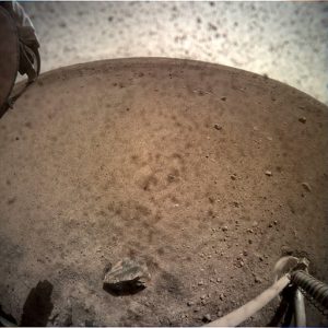
Launched from Earth last May, the InSight spacecraft successfully landed on the surface of Mars on November 26 to the cheers of engineers at Mission Control in Pasadena, California. The cheers were well deserved given that the success rate of previous Mars missions from various countries has been only 40 to 50 percent. Unlike earlier Curiosity and Opportunity missions, InSight is no rover. Rather than roam the surface, taking photographs while collecting and analyzing soil and air samples, InSight will stay put and will drill deep.
While previous Mars missions have been designed to photograph and map the planet, analyze its atmosphere, and search surface soils and rocks for water and signs of past or current life, InSight will help us understand the deep underlying geology of the Red Planet. Scientists hope the information gleaned will teach us not just about Mars but also about how other rocky planets, like our own Earth or Venus, formed and evolved and why they differ. Two specific tools are involved: 1) a super-sensitive seismometer to measure quakes and thereby tell us about the interior layers and core of the Red Planet, and 2) a motor- and spring-loaded probe that will drill 16 feet beneath the surface to measure heat and to give us a better handle on how heat has dissipated within Mars since its formation.
It is deep-down heat within Earth that drives plate tectonics and our magnet field. Mars is much smaller than Earth and has lost much of its heat, making it much less geologically active than in its past. The heat probe will help scientists get a better handle on the heat still residing within. The core is still believed to be molten but is not releasing enough heat for the sort of geological activity we see on our own planet.
InSight represents a truly international effort, with the U.S. taking the lead on overall mission design and launch, Germans designing the mechanical “mole” to dig 16 feet down, and French directing the quake-monitoring seismometer. “InSight”, by the way, stands for “Interior Exploration using Seismic Investigations, Geodesy and Heat Transport”. Watch for many insights to come!
Earthquakes Show No Deference to Two Traditional Enemies in Iran and America
On November 25, a magnitude 6.3 earthquake near Sarpol-e Zahib in western Iran sent people running into the street and injured over 400. The quake was centered near the site of an earthquake that killed over 600 last year. Fortunately, this year the number of injured was much fewer, with only 15 so far reported as hospitalized.
Shortly thereafter, Alaska was struck by a magnitude 7.0 earthquake on November 30 centered 7 miles north of Anchorage. It was the most significant earthquake to strike the area since 1964. The quake caused extensive damage, including rock slides, sinkholes, buckled roads, bridge collapses, and power outages for some 30,000 people. Buildings were rocked and at least one home burned from ruptured gas lines. Accounts of injuries and damage continue being reported, as do hundreds of aftershocks that are still rippling out across the region, including one that measured magnitude 5.7.
Fortunately, as of this reporting, no deaths or serious injuries have been recorded. It is said Alaska averages an earthquake every 12 minutes somewhere in the state (more than all other U.S. states combined), but few are of this scale and scope.
Author: Jim Brace-Thompson
 Founder and overseer of the AFMS Badge Program for kids.
He’s also an inductee of the National Rockhound & Lapidary Hall of Fame within the Education Category.


